OceanEyes technologies
Ocean data assimilation
Wide area marine environments forecast using numerical ocean models
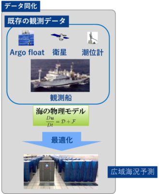
- Prediction of wide area oceanic condition based on ocean physical model It is a technology to predict the sea condition such as sea water temperature over a wide range by model calculation using a large computer.
- Wide area prediction of the ocean is obtained by optimizing observation data that satellites, observation buoys, and observation vessels provide based on the ocean physical model. This calculation requires a large amount of computer resources, and the latest supercomputer is used.
- Because the model calculation requires a large amount of computer resources, the latest supercomputers are used.
- Marine environments forecast is mainly provided by public organizations of each country. Generally, forecast is still mainly done at the resolution of 10 kilo-mesh. Ocean Eyes technology can forecast oceanic condition up to 14 days into the future with a resolution of about 2 kilo mesh. In the future, we plan to develop a physical model with a higher resolution.
OnSpot ocean condition forecast
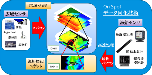
- Although prediction of the ocean condition based on the physical model of the sea is highly accurate, it was difficult to forecast the range that can be directly used for fishing activities. We have developed a technology to realize the prediction range of 10 km units in the finer range of 100 m by utilizing data from sensors mounted on vessels such as fishing boats. We call this technology “OnSpot ocean condition forecast”.
- With this “OnSpot ocean condition forecast” technology, it is now possible to provide more useful information for fishery activities, such as determining more detailed fishing ground decisions and netting timing.
Ocean pattern analysis
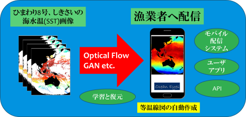
Automatic creation of isotherm diagram
- In the sea fishery field, decisions on which seas to fish are important decision-making items affecting landing and fuel consumption. Isotherm diagrams provided by public institutions etc. are widely used for fishing ground decisions.
- In this way, seawater temperature is an important information used to determine fishing grounds, but now it is drawn by hand. In addition, although surface seawater temperatures can be monitored by meteorological satellites, it is not possible to obtain seawater temperatures in all sea areas immediately because they are blocked by clouds.
- To solve this problem, Ocean Eyes has developed a technology that can remove clouds at a high speed from ocean temperature images generated by satellite observation data, and create isotherms as soon as possible.
- By using the image reconstruction technique of the deep learning system, we greatly reduced the calculation cost and automated the preparation of the isotherm diagram itself than before. This greatly improved the frequency of renewal and the timing of renewal, making it possible to make a big contribution to improving the efficiency of fishery.
Estimated fishing veteran fisherman’s experience x Pattern analysis
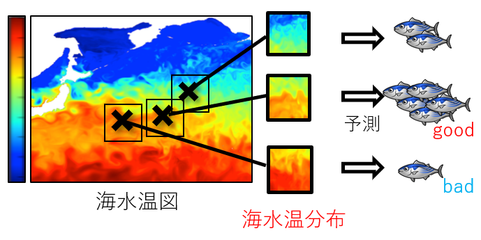
- At the fishing site, based on isotherm charts etc, veteran fishermen decide the sea area to be fished by experience and intuition.
- However, due to the aging and decreasing number of fishers, it has become impossible to pass on such fishing ground decision skills. As a result, there is a big difference in landing between young and experienced fishermen.
- We developed a technique to imitate the skill of veteran fishermen and to estimate the fishery which is well captured by performing pattern recognition of catch data and seawater temperature distribution.